Monday, June 25, 2012

The latest on Debby

The predicted direction of Debby has changed once again. She is now moving Northeastward at 5 mph. Sustained maximum winds have dropped to 45 mph. The predictions of Debby increasing to 70 MPH have been reverted. Since T.S. Debby stayed stationary for such a long time over the gulf, cold upwelling has cut off the warm water energy source. Also, mid level dry air has affected strengthening. 


The latest track shows Debby moving inland over North Central Florida by Monday and emerging over the Atlantic by Saturday morning. 

Continued weakening is expected now that the ocean upwelling and dry air are interacting. Tropical Storm warnings are in effect for the areas from Destin to Englewood, Fl.

The strongest winds and heaviest rain are located away from the center.
Waves of heavy rain will make their way onto the state periodically since the storm is moving so slowly. 
This is an image from Monday June 25 at 2:37 PM EDT

This is a URL image so it will change as it is updated on the website.


Sunday, June 24, 2012

Debby Drowner or Doubtful Debby?

No matter which alliteration you prefer, Debby is making it really difficult for meteorologist to forecast. (There goes another one "Difficult Debby") The forecast cone has been going through several edits  this past weekend. On Friday, the NHC showed a path that took Debby to Texas but today as Debby stands stationary over the gulf, the cone is actually a circle. 


Watches include the areas from the south of the Suwannee River to Englewood, Florida and Warnings go from The Mississippi-Alabama boundary toward the Suwannee River. This a wide area of Warnings and Watches mainly because the Forecast Models have not been in accordance. These discrepancies have a lot to do with the weak steering flow aloft.


The NHC has low confidence in their forecast track because of all the discrepancies but they have decided to confide in the models that have been the most correct throughout the lifespan of this storm.

Currently, Debby is at 28.3N 85.9W with sustained maximum winds at 60 MPH. Probably the worst fact is that she is stationary. The latest advisory from the NHC doesn't show Debby on land until Friday. They hope by then upwelling and land interaction will have downgraded the storm but before then, Debby is expected to strengthen a little. They have posted her reaching 70 MPH in 48 hours.
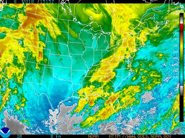
As of now this is what she looks like in the GOES color enhanced imagery:


But what does all this mean for people in areas that are not under Watches or Warnings??

For one: it means RAIN and a lot of it. These past few days, parts of South Florida has seen more than 4 inches of rain.


This image from the NWS MIAMI Facebook page shows the total rainfall amounts since Wednesday.
Another threat that Debby is bringing upon the entire Florida Peninsula is Tornadoes.


http://www.spc.noaa.gov/products/wwa/
As of 1114 PM EDT there are Tornado Warning for
  NORTH CENTRAL BREVARD COUNTY IN FLORIDA...
  THIS INCLUDES THE CITIES OF...SHARPES...TITUSVILLE AIRPORT...
  TITUSVILLE...PORT SAINT JOHN...MIMS...LONE CABBAGE FISH CAMP...
  COCOA..
 Watches Extend throughout the state. For more information check out your local NWS station alerts and advisories. They are where your local news get their information so checking them out first will be quicker.

As of now severe squalls are making their way throughout the state creating dangerous conditions. These storms are capable of producing tornadoes.


For the next few days I expect a lot of Flood advisories for the Florida Panhandle as Debby moves ever so slowly. I also expect more waves of thunderstorms to come ashore from the west and move throughout the state. Severe weather is expected throughout the week. So have a plan and an umbrella or raincoat at hand the whole week. Keep your eyes out for warnings and watches throughout the week.

Friday, June 15, 2012

Carlotta Becomes a Hurricane!

Although the center of Carlotta has moved onto slightly cooler waters,  she has become stronger. She is now a Category 1. Currently, Hurricane Carlotta has maximum sustained winds of 74 Kts. Minimum pressure as of 11 AM PDT is 979 mb. Satellite imagery shows that the central dense overcast has become more organized and that an eye has been formed. These are sure signs that the hurricane has become stronger. 

Carlotta over waters at around 31C
Eye wall formation seen through the GOES visible imagery


Carlotta is undergoing rapid intensification just as she's nearing the coast. Although the forecast keeps her offshore, the possibility of the mountains deteriorating conditions is possible. The models generally agree that Carlotta will be looping back around. After Saturday, however Carlotta is expected to become a tropical storm. 
A defined eye and cirrus outflow can be seen in this GEO image. 

Model Tracks generally agree on looping around over the Mexican Coast

Hurricanes Warnings are in effect from Punt Maldonado to Acapulco. Watches are in effect from Salina Cruz to Barra de Tonelada and West of Acapulco to Tecpan de Galeana.


Although the possibility of complete dissipation is possible if the storm passes over the mountains, hazards that are probably include mudslides and flash flooding!

Thursday, June 14, 2012

Carlotta in the Eastern Pacific

All eyes on the Eastern Pacific as Carlotta nears the Mexican Coast
 

Satellite Imagery from http://www.nrlmry.navy.mil/TC.html


The imagery shows us how large the extent of this eastern Pacific storm expands. Rain bands will affect areas in Central America even though landfall is expected in Mexico. As you can see, the storm shows a central dense overcast that is not well defined. Nor does it have a structured eye wall. But the outflow is looking favorable for the storm's future.


This image from Weather Underground shows that the ocean temperatures where Carlotta is located are way above the required 26C; up to and probably above 90degrees Fahrenheit! 
Right now estimates show a 45knot wind speed. A mid upper level ridge and middle level trough are steering the storm toward the north east. (NHC) Models show that the storm can reach up to 90Kts within 48 hours which will be around the time that Carlotta will be nearest to the coast. That being so, the areas between Acapulco and Tehuantepec, Mexico are under Hurricane Warnings/watches. While Carlotta is not expected to come onshore, any interaction with the Mexican mountains will not be favorable for the storm. However, heavy winds and rain will still be a factor this weekend.

Sunday, May 20, 2012

Welcome Alberto!

Officially, hurricane season is from June 1st to November 30th. This season has started much earlier than anticipated. Today the first Tropical Storm of the season was named. Alberto was first announced as a tropical storm late on Saturday afternoon on May 19 2012.

As of the 11PM (EDT) advisory Alberto is at 31.8N 78.5W, off the coast of South Carolina.


The NHC reports winds to be about 45knots. It is however moving southwestward at 5 kts into an area of dry air and higher shear. Then it will move north eastward. The storm however is moving rather slow so for the moment and for some time it will remain at about 45 knots. While tropical storm force winds are not quite on shore, the NHC has decided to issue a Tropical Storm watch for the Southern South Carolina Coast. They also forecast Alberto to become Extratropical by the 96hr forecast and dissipation by 120 hrs. 


Monday, April 30, 2012

Since classes are out for the week and it is raining excessively the entire day, I thought it would be the perfect time to start this WLOG. Perhaps, I should introduce myself first. My name is Javiera Hernandez. I graduated from the University of Florida in 2011 with a Bachelor's in Geography and Certification in Meteorology and Climatology. Currently I am working on a Master's degree in Geosciences with a concentration on atmospheric science at Florida International University. This WLOG will consist of weather discussions and random forecasts for  South Florida. However, other places of interest might pop up. :)